
Investigating a Collapsed Tunnel After a Landslide in the Swiss Alps
A road tunnel in the Swiss Alps was struck by a landslide, cutting off access to a village and disrupting a popular ski resort. The Elios 3 drone played a crucial role in assessing the damage and planning a safe response to the incident.
Key Benefits in a Nutshell
|
Safety The unstable conditions inside the tunnel made it too dangerous for human entry. Authorities used the Elios 3 to gain situational awareness without risking lives. |
Efficiency The Elios 3 was deployed quickly and captured both LiDAR and visual data simultaneously, allowing for rapid investigation and response planning. |
|
Analysis The LiDAR scans from the Elios 3 provided detailed point cloud data, giving authorities a clear view of the tunnel’s interior and the path of the landslide. |
Speed Thanks to the fast deployment, repair work started quickly, and the tunnel was reopened in June of the same year, minimizing disruption before the busy summer season. |
Landslides are a common natural hazard around the world, often triggered by factors such as mountain shape, deforestation, construction, and climate change. In Switzerland, landslides are more frequent in early spring due to shifting weather patterns that can dislodge materials and cause sudden movement.
A Landslide in the Swiss Alps
On the night of February 3rd, 2024, several landslides occurred in the Riddes valley, leading to partial collapse of a road tunnel between Riddes and La Tzoumaz. This disrupted access to nearby villages and cut off parts of a major ski resort. Every day the tunnel was closed meant longer detours for residents and tourists, making it essential to understand how long the closure would last.
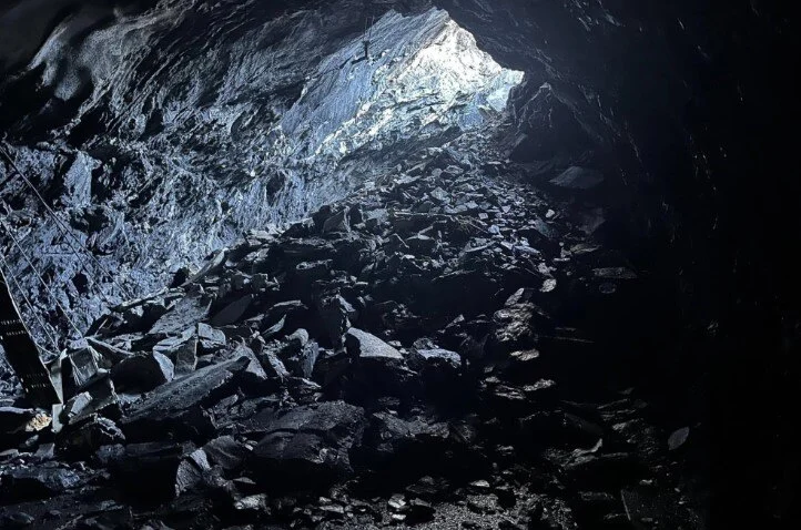 The interior of the tunnel was covered in debris. Image credit: Canton Valais
Accessing the tunnel was extremely dangerous, so traditional methods were not an option. However, getting timely information about the situation was critical to plan repairs and manage the impact on the community.
In the heart of the Alps, local authorities turned to innovative solutions to gather the necessary data.
Planning a Landslide Investigation with Drones
The landslide occurred in the canton of Valais, where local authorities needed to determine the cause and extent of the damage to the tunnel. A full investigation aimed to improve future landslide prediction and mitigation strategies.
Due to the site's instability, physical entry into the tunnel was not possible. So, the Valais authorities opted for a remote survey using the Elios 3 drone equipped with a Surveying Payload. Their goal was to capture images, videos, and LiDAR data to fully understand the tunnel’s condition and the causes of the collapse.
This project was managed by the Department de la Mobilité du Territoire et de l’Environnement, part of the Valais state authorities. Since the infrastructure is under their control, no external parties were involved during the initial investigation phase.
Flying a Drone in a Collapsed Tunnel
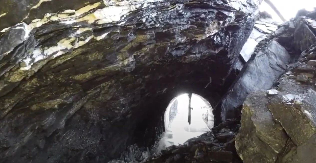
The tunnel, which had been in use for decades, may have contributed to its collapse. During construction, a small window was added to allow natural light and air, but this feature may have weakened the structure over time.
Within 24 hours of the event, the drone pilot from Valais began planning the mission. The area around the window became the primary focus of the investigation. Multiple flights were conducted using the Elios 3 to collect detailed data.
The visual feed from the Elios 3 showed how the landslide caused the tunnel roof to collapse
The first flights focused on mapping the layout of the debris and understanding the damage. LiDAR surveys were a key part of the data collection process.
Subsequent flights examined the window and its potential role in weakening the tunnel structure. High-resolution photos and videos were collected for further analysis.
Findings from Drone Surveys in the Collapsed Tunnel
The images from the Elios 3 revealed the long-term effects of the tunnel’s design. When it was built in the 1960s, the open window allowed cold air to enter, accelerating freeze-thaw weathering inside the tunnel. Over time, this led to cracks and structural weaknesses.
It’s also believed that the initial excavation used explosives, which may have caused decompression in the surrounding rock. This could have weakened the outer walls of the tunnel, making it more vulnerable to failure.
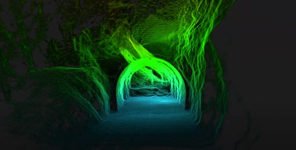
Clear visualization: the LiDAR scan shows the layout of the collapsed tunnel section and where the rocks came through
Over the years, the rock around the window developed faults that were gradually weakened by weathering, vibrations from traffic, and minor seismic activity. By the time of the collapse, the structure had become significantly unstable. In late 2023, there were signs of movement, including small rockfalls that reduced the strength of the rock pillar separating the tunnel from the surface.
The Impact of Drones in Emergency Response
Without the Elios 3, it would have been extremely difficult to assess the situation safely. Sending personnel inside was not an option, so teams would have had to secure the area first, delaying recovery efforts and prolonging the closure of the tunnel and surrounding areas.
The fly-through of the LiDAR scan shows the full extent of the damage
The use of the Elios 3 made a huge difference in this case. Investigators were able to enter the affected tunnel just one day after the incident, providing a much faster response than traditional methods. In the past, securing a landslide could take days or even months before any assessment could begin.
By using drones, the Valais authorities were able to gather critical data quickly and safely, reducing the number of people needed on-site and speeding up the entire process. These findings will be used in the ongoing repair of the tunnel and in future investigations across the region, especially as climate change increases the risk of unpredictable geological events.
R290 Pool Heat Pump, Full Inverter Heat Pump, Pool Heater
FOSHAN UWOTEC NEW ENERGY CO., LTD. , https://www.uwo-heatpump.com